
Wednesday walk Medium-Hard: unnamed creek in Tallaganda
Wed 26th Feb 2025
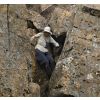
On this walk we will be cascade-hunting by following an unnamed tributary of Mulloon Creek, in northern Tallaganda NP. The aim is to follow the creek as closely as possible, even where that means wet feet. We start with a car shuffle. The first 1.5 hours of walking will be through forest, some semi-open, some scrubby, some dotted with purple Dianella berries. For the next couple of hours we will follow the creek downstream, then upstream beside Mulloon Creek, ending at the pleasant Mulloon camping area for afternoon tea. The leader has done this walk previously by looking at the 1 km-long chain of cascades on the unnamed creek from nearby spurs, but not followed the creek closely. The image shows the creek upstream of where it starts to get properly interesting . The walk is a mix of easy and hard - easy because it is nearly all downhill or flat, will be at a moderate pace with time for some photography, and the water levels are a little below average. Hard because it is almost all off-track. A few sections are scrub-covered boulder fields. There are steep, loose slopes. Some rock scrambling. Walking poles not recommended for most of the day: they are more likely to be a liability than a help in the rough sections. We will drive part of the Sth Black Range management trail, which is best done with AWD/4WD.
Meet at the Spotlight Queanbeyan carpark at 8.10 am, ready for a departure no later than 8.15 am. If there are not enough AWD/4WDs, it will be first come, first served. Bring shoes you are happy to get wet, and dry foot gear to leave in the car.
No need to book. If you are uncertain of your ability to do this walk please contact the leader at least 24 hours prior to the walk.
Additional Information
Length
Short
Terrain
Rough
Conditions
Partly Exploratory Partly Wet
Distance (km or hrs)
7 km
Ascent
50 metres
Descent
400 metres
Map name
Bombay 1:25,000
Terrain information
Nearly all off track. Forest, some semi-open, some scrubby and rocky, fallen logs, uneven ground. Steep loose slopes, rocky creek. Creek wading likely. Rock scrambling.
Transport information
$40 per car.
A walk or similar activity with a duration of a day or part day. No overnight gear required.
Date and Time
Activity Owner
linda-groom01
Linda Groom