Tianjara Cliffs and Canyons - revised walk
Sat 07th Mar 2026
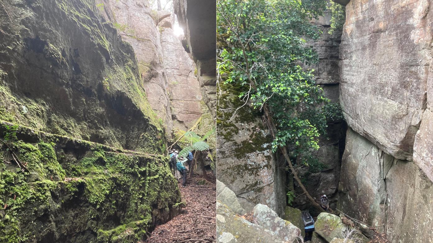
Two stages with short drive between. Start at Tianjara Falls Lookout carpark. Head north, across a creek and high waterfall. Then down ramp to bottom of cliffs and continue north. Two canyon systems to explore (one optional), both cutting deep into cliffs. One is smaller than but about as spectacular as the Labyrinth - narrow moss-covered high walls in T-shaped canyon. Other, bit less so, but still pretty special. Return via cliff top or cliff base and then top. Some bush bashing.
Then drive east a few kilometres to park and walk (1.7km) into the cliffs above the Labyrinth. Outstanding views, then walk around ragged cliff edge to hidden entrance to Labyrinth. Descend through multiple passages and chambers, running hundreds of metres to exit at base of cliffs. Scope to bush bash down to the old logging trail. Return same way to the cars.
For those unfamiliar with the spectacular Tianjara canyon country, the following link provides several photos I took on a recent reccy of the Labyrinth - to make sure is was still accessible. It was. You will notice in IMG_4611 that my wife is in the shot, down the far end of that chamber (one of several). This provides some sense of scale, especially the height and vertical nature of the canyon sides, though the passage gets much narrower in places, as you move between chambers. I do not think the link below is active - you will probably need to copy and past into a browser. It is necessary to get up some ledges, and to crawl through some near tunnels as we approach the exit. I would love to have a geologist along who could tell me more.
https://1drv.ms/f/c/da6eb55e37ef16ad/IgBUgadErHkcTLMps3DqHiSuAW9wambRGEQ53A1NU3DlmLY?e=9BTHwq
Additional Information
Booking deadline
Wed 04th Mar 2026 05:00pm
Length
Medium
Terrain
Rough
Distance (km or hrs)
9 hours (14 km, slow progress in places)
Ascent
250m
Descent
250m
Map name
Sassafras
Terrain information
Mostly off-track, frequently steep. Initially, tracking down Yarramunmun Creek for some kilometres - with some rock hopping, steep falls etc. Climb back out involves thick bush bashing for a short distance, then steep climbing to the old fire trail. Easy contour walking till approaching the Labyrinth - then some rock scrambling and possible use of a rope at one or two points. Once out of the Labyrinth, mainly on track back to cars.
Transport information
If coming from Canberra, would strongly recommend car pooling. The roads are fine (though watch for potholes) - only a few metres of dirt road into the walk start, off the Braidwood Road. When booking, let me know of you would want any help in pooling, or want to offer to take others. An alternative, given the walk is on a Saturday, would be to come through to the coast (St Georges Basin, Nowra etc) and stay the night. Will provide detailed directions to meeting spot.
A walk or similar activity with a duration of a day or part day. No overnight gear required.
Date and Time
Activity Owner
